Helpful Surveying software
In this technocratic world...various software are making engineering simple. Likewise in surveying of civil engineering there are top software which are very useful.
Here is the list of best software which are useful in Surveying.....
Here is the list of best software which are useful in Surveying.....
AUTOCAD
Auto CAD is one of the civil engineering software used all over the world. The output files from the Surveying equipment like Total Station can be analysed using Auto CAD.
ArcGIS
ArcGIS for Desktop is the key to realizing the advantage of location awareness. Collect and manage data, create professional maps, perform traditional and advanced spatial analysis, and solve real problems. Make a difference and add tangible value for your organization, your community, and the world.
SURFER 13
Surfer is a Contouring and surface modelling software that is available for windows platfom.
Surfer is used extensively for terrain modeling, bathymetric modeling, landscape visualization, surface analysis, contour mapping, watershed and 3D surface mapping, gridding, viewshed analysis, volumetrics.
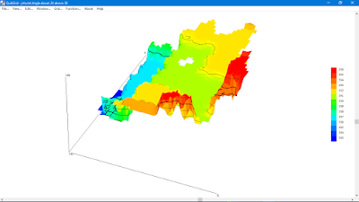
QUIKGRID
Users can render the 3D interpretation of Data Points. Its a free software.
TCX Convertor
It lets you convert various file formats of generated contouring files.
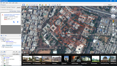
Google Earth
Explore the world with Google Earth.
>Explore rich geographical content.
>Visualize your GPS tracks and share with others.
>Fly around cities (or the entire world) in 3D.
>Visualize your GPS tracks and share with others.
>Fly around cities (or the entire world) in 3D.
RELATED:
ABOUT SURVEYING:
Surveying or land surveying is the technique, profession, and science of determining the terrestrial or three-dimensional position of points and the distances and angles between them. A land surveying professional is called a land surveyor. These points are usually on the surface of the Earth, and they are often used to establish land maps and boundaries for ownership, locations like building corners or the surface location of subsurface features, or other purposes required by government or civil law, such as property sales.
Surveyors work with elements of geometry, trigonometry, regression analysis, physics, engineering, metrology, programming languages and the law. They use equipment like total stations, robotic total stations, GPS receivers, retro reflectors, 3D scanners, radios, handheld tablets, digital levels, drones, G.I.S and surveying software.
Surveying has been an element in the development of the human environment since the beginning of recorded history. The planning and execution of most forms of construction require it. It is also used in transport, communications, mapping, and the definition of legal boundaries for land ownership. It is an important tool for research in many other scientific disciplines.
Via Wikipedia.
Here is a quick tip. If you are looking for super cool travel gifts, then check this travel journal from JOTJOY. JOTJOY's travel journals are highest rated and best-selling journals on Amazon India.
Use code CIVILSCHOLAR at checkout to get an additional discount.
Explore all products here: JOTJOY
Surveyors work with elements of geometry, trigonometry, regression analysis, physics, engineering, metrology, programming languages and the law. They use equipment like total stations, robotic total stations, GPS receivers, retro reflectors, 3D scanners, radios, handheld tablets, digital levels, drones, G.I.S and surveying software.
Surveying has been an element in the development of the human environment since the beginning of recorded history. The planning and execution of most forms of construction require it. It is also used in transport, communications, mapping, and the definition of legal boundaries for land ownership. It is an important tool for research in many other scientific disciplines.
Via Wikipedia.
Quick Tip:
Here is a quick tip. If you are looking for super cool travel gifts, then check this travel journal from JOTJOY. JOTJOY's travel journals are highest rated and best-selling journals on Amazon India.
Use code CIVILSCHOLAR at checkout to get an additional discount.
Explore all products here: JOTJOY

